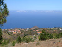
Santa Cruz de La Palma -
45km square with approx. 18,000 inhabitants
A coastal town which is also the capital of
the island. Having travelled the Canaries and visited most of
the major towns, this has got to be one of the most relaxing
and scenic to walk around. Much of the town comprises of the
origional buildings, especially the religious and civil buildings,
which have been carefully looked after and/or restored through
the last 500 years or so.
The main road (LP1) that runs through the town
paralells the sea, passing the beach and harbour. There's regular
ferry services from here to Tenerife, limited service to mainland
Spain and often the large cruise ships stop here too. On the
other side of the road is a very good choice of bars, very nice
and friendly atmposphere and good to head for in the evenings.
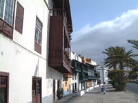
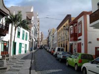
Many of the town's buildings support the traditional
Canarian woodern balconies and brightly coloured facades lining
cobbled streets. Away from the main coastal road that runs through
the town, you step back in time a little as you walk through
Santa Cruz. The main square, Plaza de España is a good
place to head for where you'll also find the church of El Salvador.
Other buildings to look for, if that's your
thing, include Palace of the Counts of Salazar, temple of Santo
Domingo, temple of Nuestra Señora de las Nieves with
its neighbouring art gallery, castle of Santa Catalina and convent
of Sant Fransisco.
Of the celebrations to look for, the main one
is extremely hard to time in to your holiday schedule (but well
worth it) as it only takes place once every five years! La Bajada
de la Virgen de las Nieves. Preceded by a huge pilgramige to
Santa Cruz, there's 18th-century styled festivals, floats and
dancing with "the dance of the dwarfs" - complete
in amazing dwarf costumes!! |
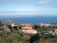
Los Llanos de Aridane - 35
km square and approx. 20,200 inhabitants
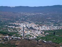
La Palma's "second city" situated
towards the west coast of the island. This is certainly the
agricultural capital of the island. The surrounding valley of
Aridane being very fertile and home to vast banana plantations.
Closer to the coast is the resort and beach of Puerto Naos.
Whilst I personally found the town of Los Llanos
(Los Llanos means the flats - this part of theisland being flat!)
nice but nothing worth going out of your way for, I have to
say the valley of Aridane (where it's located) is one of the
nicest parts of the island. The view down into the valley from
Tijarafe one of the most amazing of the island. |
Tazacorte - 12 km square
and approx. 7,000 inhabitants
Still in the valley of Aridane, close to Los
Llanos.. Close buy is "EL Puerto" - the port with
beach. Fishing is very popular from here, the palm groves are
worth seeing and the town celebrates their patron saint on 29th
July each year. |
El Paso - 135 km square and
approx. 7,500 inhabitants
The other side of Los Llanos towards the higher
part of the valley of Aridane (it's a big valley this!) is El
Paso. Known as the city of the Almond Trees the most fascinating
tradition/craft about this town is "caterpillar breeding"
as natural silk is produced here. Look for Bertila Perez' workshop
where you can see the craft in action and admire her works,
of course, you can buy silk here too.
Lush green countryside, pine-forst-covered
hills and banana plantations border this town with an abundance
of almond trees and palm groves also to pass through make the
pretty town of El Paso well worth a visit. |
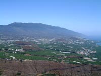
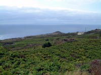
Tijarafe - 55km square and
approx 3,000 inhabitants
Another town set amidst palm and almond trees,
otherwise pretty unspectacular and I wasn't impressed - until
I reached the mirador at the edge of the town, "El Time".
From here you have THE most spectacular, birds-eye view over
the entire valley of Aridane and down the west coast. I went
on two different days, the first a clear day and the second,
what little cloud was scattered around was actually on a level
or below me. |
Puntagorda - 32km square
and approx. 2,000 inhabitants
Towards north-west coast, this was a bit of
an oasis to arrive at after driving along the north-coast road
that runs through the forest there (You'll see what I mean if
you do that drive).
Yet another town of almond trees (by the way,
January and February is when they bloom), it's traditional buildings
(and strict building laws) help make the town one of themost
picturesque on the island. The locals here really show how well
the land on the island can be farmed as almost the entire town
survives on agriculture.
Puntagorda was once famous for its mills although
few ruined examples now remain. The cereal gofio was milled
here for the entire island. |
Garafia - 100km square and
approx. 2,000 inhabitants
Right on the north-west coast, this is a village
rich in water reserves and fertile land suitable for cattle
and goat farming. The latter is more commonplace with goat's
cheese a popular produce here. The village is set admidst steep
ravines, forests of laurel and dragon trees.
|
Fuencaliente - 56km square
and 2,000 inhabitants
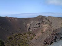 
Located towards the very south of the island
a much more barren part of the island as this is where the island's
volcanos are also located. You'll undoubtadly pass through this
town if going to visit or walk through the volcanos.
One crop that does thrive in the remaining
ashes and is apparent all down the south-west coast is the grape-vine.
Around one million litres of wine a year are produced here.
Close by are some of the nicest, clear-water beaches on the
island such as EL Faro, Playa Nueva, Punta Larga and La Zamora. |
Barlovento - 44km square
and 2,500 inhabitants
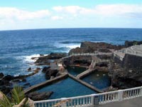 
Situated in the wettest part of the island,
the north east, home to very fertile land, all sorts of crops
and some beautiful forests. With the land being so fertile here,
the locals have made the most of the space they have and have
terraced layers out into the mountains to plant their crops,
mainly bananas but also potatoes and other vegetables.
One of the areas near the town is La Tosca,
home to a dragon tree cluster. To thenorth of the village is
La Laguna, a reservoir capable of holding 5 million cubic meters
of water and surrounded by a protected park.
Towards the coast are the Piscinas de Fajana
- an area where man has helped develope natural areas of rock
in the water to create swimming pools. |
San Andres y Sauces - 44km
square and approx. 5,500 inhabitants

An area developed after the conquests thanks
to the sugar cane. Though long gone, the towns remained and
the land uused for the banana crop. Whilst some locals also
cultivate their own crops such as tobacco, 99% of the land here
is given over to bananas.
The place most tourists head for here though
is the Los Tilos forest, a vast sylvan-lorel forest which has
in its center underground springs, a river and cascading waterfalls
thans to the low, moist cloud and rains in this part of the
island. The river's been harnessed in one part by a power plant
which uses the force of the water to provide a total of 7% of
the islands power.
I liked Los Sauces a lot, very peaceful way
of life there, nice and friendly tapas bars, a peaceful town
square to enjoy the views past the church and down to the coast. |
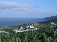
Breña Baja & Breña
Alta - 40km square and approx 10,000 inhabitants
This is the area around the island's capital, Santa Cruz. Beginning
at the peek of the mountain above the town (Breña Alta)
and going down to the coast (Breña Baja) and the resort
of Los Cancajos. Tobaco is a popular crop and craft (hand-rolled
cigars) here.
Los Cancajos is the main tourist area of this part of the island.
A nice place to stay as you're just 10 minutes drive/bus from
the capital on one side and the airport (not that busy/noisy)
on the other. |
|